India's Location and Extent
Learning Objectives
- Identify the extreme points and coordinates that define India's mainland boundaries
- Explain why the north-south distance exceeds the east-west distance despite a similar degree span
- Understand the climatic significance of India's latitudinal position
- Describe the purpose of the standard meridian and Indian Standard Time
- State India's total area and its rank among the world's largest countries
India’s Location and Extent
Take a look at a map of the world, and you will notice that India sits right at the crossroads of Asia, with the Indian Ocean sweeping along its southern edge. But where exactly does India begin and end? And why does the sun rise in Arunachal Pradesh a full two hours before it rises in Gujarat, yet clocks across the country show the same time? Understanding India’s coordinates, its spread across latitudes and longitudes, and the clever fix of a standard meridian answers all of these questions.
How Far Does India Stretch?
Picture the Indian mainland as a giant quadrilateral: Kashmir sits at the top, Kanniyakumari at the bottom, Arunachal Pradesh forms the eastern edge, and Gujarat the western one. India’s territory does not stop at the shoreline, though. The country claims a belt of territorial waters stretching 12 nautical miles (a unit used for sea distances, roughly 1.852 km each) outward from the coast, which adds about 21.9 km of sovereign water on every side.
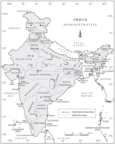
Fig 1.1: India: Administrative Divisions
The southernmost reach of Indian territory is not Kanniyakumari itself but a point much further south in the Bay of Bengal, at N latitude, where the Andaman and Nicobar Islands extend India’s boundary.
Quick reference: Miles and Kilometres
Unit In inches Approx. in km Statute mile 63,360 1.584 km Nautical mile 72,960 1.852 km A nautical mile is longer than a regular (statute) mile. Sea and air navigation use nautical miles because they connect neatly to degrees of latitude.
Thirty Degrees Each Way, but Different Distances
Here is a fact that surprises many students: India covers roughly 30 degrees of latitude (north to south) and roughly 30 degrees of longitude (east to west). The degree spans are almost equal. Yet the actual ground distances are not:
| Direction | Degree span | Ground distance |
|---|---|---|
| North to south | ~30° | 3,214 km |
| East to west | ~30° | 2,933 km |
Why the gap? It comes down to how the Earth’s grid works:
- Latitude lines (parallels) are evenly spaced. One degree of latitude equals about 111 km no matter where you are on the globe.
- Longitude lines (meridians), on the other hand, fan out widest at the equator and squeeze together as they approach the poles. So one degree of longitude covers less ground at India’s latitudes (roughly to ) than one degree of latitude does.
Since India sits well north of the equator, the 30 degrees of longitude translate into a shorter physical distance than the 30 degrees of latitude.
Why Latitude Matters for Climate and Landscape
India’s latitudinal spread has a direct and major impact on the kind of climate, soil, and plant life found across the country. The Tropic of Cancer () runs almost through the middle of India, splitting the country into two broad zones:
- South of the Tropic of Cancer — the tropical zone. This region receives more direct sunlight throughout the year, leading to warmer temperatures, heavy rainfall in many areas, and lush vegetation.
- North of the Tropic of Cancer — the sub-tropical or warm temperate zone. Winters here are cooler, seasonal contrasts are sharper, and the landscape ranges from fertile plains to snow-capped mountains.
The practical result is striking: a single country holds everything from snow-bound peaks and temperate forests in the north to scorching deserts and lush equatorial-style coastlines in the south. Climate, soil, landforms, and plant life shift dramatically as you travel from one end to the other.
What the Longitudinal Spread Means for Time
India’s 30-degree east-west longitude span has a very practical consequence: local solar time differs by about two hours between the eastern and western edges of the country. When the sun rises over Dibrugarh in Assam, it is still dark in Jaisalmer, Rajasthan. If every town simply followed its own local sun time, coordinating train schedules, flights, and business across the country would be chaotic.
The solution is the standard meridian.
The Standard Meridian and Indian Standard Time (IST)
Internationally, the practice is to choose a standard meridian whose longitude is a multiple of . Why that number? Because of longitude equals exactly 30 minutes of time (the Earth rotates through every hour, so half of that, , equals half an hour). Picking multiples of guarantees that the country’s time offset from Greenwich Mean Time (GMT) lands on a neat half-hour or full-hour mark.
India selected as its standard meridian. This line passes roughly through the centre of the country. The resulting offset is:
So Indian Standard Time (IST) is GMT + 5 hours 30 minutes. Every clock in the country, from Imphal in the northeast to Jaisalmer in the west, shows the same time, even though sunrise and sunset happen at noticeably different local times.
Some countries with an even wider east-to-west spread adopt multiple time zones instead of a single standard. The United States, for instance, uses seven time zones.
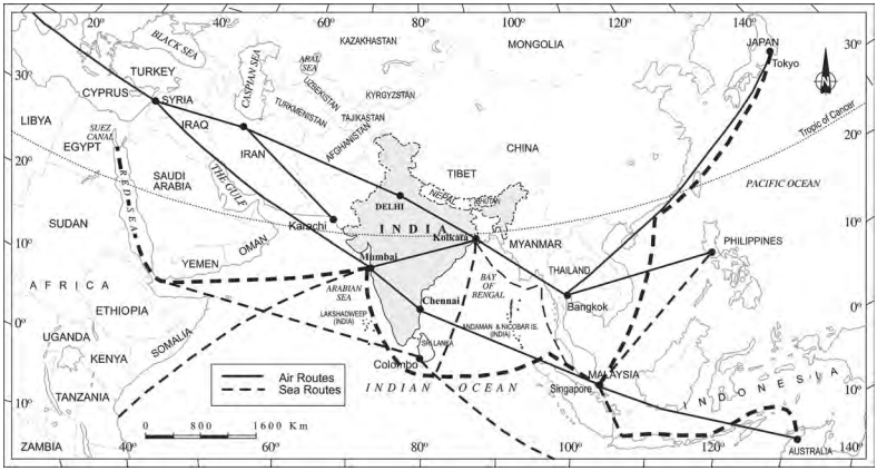
Fig 1.2: Location of India in the Eastern World
India on the World Stage: Size at a Glance
How big is India on the global map? With a total area of 3.28 million square kilometres, it takes up roughly 2.4 per cent of all land on Earth and ranks as the seventh largest country. Only Russia, Canada, the United States, China, Brazil, and Australia are bigger.
Despite holding only 2.4 per cent of the world’s land, India packs an extraordinary range of physical features into that space, from the highest mountain ranges to vast river plains, desert expanses, and long coastlines. Much of this diversity ties back to the latitudinal and longitudinal spread we have just explored.