Geography as an Integrating Discipline
Learning Objectives
- Explain what makes geography an integrating discipline and how it differs from other sciences
- Understand the concept of spatial synthesis and compare it with temporal synthesis in history
- Identify the branches of geography and their parent disciplines using the relationship diagram
- Describe how geographical factors have influenced historical events with examples from India and the world
- Explain why time is considered the fourth dimension in geographical studies
Geography as an Integrating Discipline
Think about how many different subjects touch the earth in some way. Geologists dig into rocks, meteorologists track weather, economists study markets, and historians trace the past. Each one looks at a piece of the puzzle. But who puts these pieces together and sees the full picture? That is the role of geography, and it is what makes this subject stand apart from every other discipline.
The Discipline of Synthesis: Connecting Space and Time
Geography is often called a discipline of synthesis (a field that pulls together knowledge from many sources into one connected understanding). While most subjects study a narrow slice of reality, geography tries to see how everything fits together across the earth’s surface.
There is a neat way to understand this. Geography attempts what is called spatial synthesis (organising information by how things are distributed and connected across space). History, by contrast, attempts temporal synthesis (organising events and changes through time). Both are trying to build a big picture, but geography does it across places, and history does it across periods.
This approach is holistic (looking at the whole rather than individual parts). Geography starts from a simple but powerful idea: the world is a system of interdependencies (where different elements depend on and influence one another). Nothing on the earth’s surface exists in isolation. Soils affect what crops grow, climate affects soils, trade routes affect economies, and economies affect settlement patterns. Everything is connected, and geography is the discipline that tries to trace those connections.
Why Geography Needs a Broad View
Today, the world feels smaller than ever. Better transportation has shortened distances and increased accessibility (the ease with which people can reach different places). Audio-visual media and information technology have multiplied the amount of data we can collect. Satellite systems and monitoring technologies give us the ability to track both natural events like storms and earthquakes, and social indicators like population growth and trade patterns.
All of this means that a geographer today must be comfortable working across a wide range of fields. To understand why a particular region has the crops it has, a geographer might need knowledge of soil science, climate patterns, market economics, and local history. To explain why a city grew where it did, the geographer might draw on geology, hydrology, transport studies, and political science.
This is not a weakness. It is geography’s greatest strength. Every discipline, whether natural or social, deals with elements that change from place to place. Geography helps bring those variations together into a single, connected understanding of reality.
How Geography Connects with Other Disciplines
One of the clearest ways to see geography’s integrating role is to look at how it branches out into specialised fields, each linked to a parent discipline (the broader subject from which a branch draws its core knowledge).
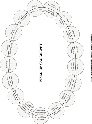
Fig 1.1: Geography and its relation with other disciplines
Connections with the Natural Sciences
Geography draws from the natural sciences to understand the physical side of the earth:
- Geology gives rise to geomorphology (the study of landforms and the processes that shape them)
- Meteorology connects with climatology (studying climate patterns and their spatial distribution)
- Hydrology links to oceanography (the study of oceans, their properties, and behaviour)
- Pedology (the science of soils) maps onto soil geography (how soil types are spread across the earth)
- Botany produces phytogeography (the geography of plant distribution)
- Zoology leads to zoo geography (the geography of animal distribution)
- Ecology links with human ecology (studying how human communities relate to their environment)
- Mathematics and astronomy connect with astronomical and mathematical geography (using mathematical tools and celestial observations in geographical study)
Connections with the Social Sciences
On the human side, geography has equally strong ties:
- Economics gives rise to economic geography (how production, trade, and consumption are distributed across space)
- Demography links with population geography (studying how populations are spread and why they move)
- Political science connects to political geography (how political boundaries, power, and governance relate to territory)
- History feeds into historical geography (examining how geographical features and patterns have changed through past periods)
- Sociology maps onto social geography (how social structures and communities vary across space)
- Anthropology links with cultural geography (the study of cultural practices and their spatial distribution)
- Philosophy connects with geographical thoughts (the ideas and philosophies that have guided how geography is studied)
- Environmental science gives rise to environmental geography (studying the interaction between human activities and the natural environment)
- Statistics and econometrics connect with quantitative techniques in geography (the use of numbers, models, and statistical methods in geographical research)
This is not just an academic exercise. Each of these branches has practical applications. Economic geography helps governments plan development. Population geography informs health policy. Climatology guides agriculture. The integrating power of geography gives it relevance across a remarkable range of real-world problems.
Geography Shapes History: Real-World Examples
One of the most striking ways to see geography’s integrating role is through its connection with history. Geographical factors do not just sit in the background. They actively alter the course of events.
Spatial Distance as a Defence
Spatial depth (the sheer size of a country’s territory) has been a powerful factor in warfare. In traditional conflicts, countries with large areas could trade space for time. By retreating across their vast territory, they gained time to regroup, resupply, and prepare counter-attacks. The enemy, meanwhile, had to stretch supply lines across enormous distances, weakening their position with every kilometre.
The oceanic expanse surrounding the countries of the New World served a similar purpose. Oceans acted as natural defensive barriers, physically preventing distant enemies from bringing wars onto their soil. This geographical protection shaped the military and political history of entire continents.
India’s Geography and Its History
India provides some especially clear examples of how geography shapes historical outcomes:
-
The Himalayas — This massive mountain range acted as a great natural barrier, protecting the Indian subcontinent from the north. But the barrier was not complete. Mountain passes such as the Khyber Pass provided routes through which migrants and invaders from Central Asia entered India over many centuries. Geography did not stop movement; it channelled it through specific routes.
-
The sea coast — India’s long coastline, on the other hand, encouraged contact rather than blocking it. People from East and Southeast Asia, Europe, and Africa all reached India through sea routes. This coastal access brought trade, cultural exchange, and new ideas.
-
Navigation technology and colonisation — When European nations developed the technology to navigate across open oceans, geography handed them a new advantage. Ocean routes gave European powers accessibility to distant lands, and this accessibility enabled the colonisation of many countries across Asia and Africa, including India. The geographical factor of ocean access, combined with technological capability, reshaped the political map of the world.
These examples show that historical events across the globe can be interpreted geographically. The causes of wars, the patterns of migration, the spread of trade, and the rise and fall of empires all carry a geographical footprint.
Time as the Fourth Dimension of Geography
Geography works mainly with three spatial dimensions: length, breadth, and height (or depth). But there is a fourth dimension that is equally important: time.
Why Time Matters in Geography
Every geographical phenomenon changes over time. Landforms erode and rebuild. Climates shift over centuries. Vegetation zones expand and contract. Economic activities evolve as technology advances. Cultural practices develop and spread. All of these changes follow a definite historical course, and understanding them requires looking at how things were, how they are now, and how they might change in the future.
Many geographical features are themselves the result of decisions made at particular points in time. A dam built fifty years ago changed the river system that exists today. A trade route established centuries ago influenced where modern cities grew.
Converting Space into Time and Time into Space
Here is a striking idea: it is possible to express distance in terms of time, and time in terms of distance. Consider two places that are 1,500 km apart. You could describe this gap as:
- 1,500 km (a spatial measurement)
- Two hours (if travelling by plane)
- Seventeen hours (if travelling by fast train)
All three statements describe the same separation, but in different terms. This ability to convert between spatial and temporal measurements is why time functions naturally as a dimension in geographical analysis. When you say a village is “three hours from the nearest city,” you are using time as a geographical measure, and everyone understands exactly what you mean.
What Makes Geography Truly Unique
Geography’s integrating character comes down to one core idea: while other disciplines study individual elements of the earth, geography studies how those elements relate to each other across space and through time. A geologist might study a rock formation in detail. An economist might analyse a market trend. But the geographer asks: how does the rock formation connect to the soil, which connects to the farming, which connects to the economy, which connects to the settlement pattern? Geography sees the web of connections that other disciplines, by their specialised focus, may miss.
This is why a geographer needs a broad understanding of many related fields. Not to replace the specialist, but to be able to logically integrate insights from different specialities into a coherent spatial picture. Geography does not simply note that things differ from place to place. It brings those differences together into a holistic understanding that recognises the world as one interconnected system.