Regional Branches and the Evolving Discipline
Learning Objectives
- Identify the four main branches of geography under the regional approach
- Distinguish between macro, meso, and micro regional studies
- Explain the difference between country/rural planning and town/urban planning
- Describe the two aspects that are common to every branch of geography
- Explain how technology has transformed the tools and methods available to geographers
Regional Branches and the Evolving Discipline
In the previous topic, you saw how geography splits into physical, human, and biogeography branches when studied through the systematic approach. But there is another way to organise the discipline entirely: look at it through the lens of regions. When geographers use the regional approach, a completely different set of branches emerges, each focused not on a single phenomenon but on understanding and shaping regions as a whole.
Organising Geography Around Regions
The regional approach, as introduced by Karl Ritter, treats a region as the unit of study. Every element within that region, whether physical, human, or economic, is examined together. When geography is classified along these lines, four main branches emerge:
Regional Studies (Area Studies): Understanding a Place at Every Scale
Regional studies (also called area studies) is the branch devoted to studying a particular area in depth. What makes it especially flexible is its ability to work at three different scales:
- Macro regional studies — Looks at large-scale regions, such as an entire continent, a subcontinent, or a large country. At this level, broad patterns in climate, population, economy, and culture become visible.
- Meso regional studies — Operates at a medium scale, such as a state, province, or a significant natural zone. This is where national-level patterns start giving way to more specific regional characteristics.
- Micro regional studies — Zooms into small areas, such as a single district, a city, or even a neighbourhood. Here, the focus shifts to local-level details that broader studies might miss.
The power of this three-tier system is that the same region can be studied at whichever level of detail suits the question being asked.
Regional Planning: Designing the Future of Places
Regional planning applies geographical knowledge to shape how spaces develop. It has two distinct arms:
- Country or rural planning — Focuses on the countryside, dealing with agricultural land use, village development, rural infrastructure, and the well-being of communities outside cities.
- Town or urban planning — Concentrates on cities and towns, addressing issues like housing, transport networks, public spaces, industrial zones, and the overall layout of urban areas.
Both types share a common goal: making sure that the physical space people live and work in is organised sensibly, sustainably, and equitably.
Regional Development: How Regions Grow and Change
Regional development examines how different regions progress over time. It looks at what drives growth in some areas while others lag behind, and studies the economic, social, and infrastructural factors that shape a region’s trajectory. This branch is especially relevant for policy-makers who need to decide where to invest resources to reduce regional inequalities.
Regional Analysis: Reading the Patterns Within Regions
Regional analysis takes a more data-driven angle. It uses models, statistical tools, and spatial techniques to examine the internal structure of regions: how resources are distributed, where economic activity clusters, how populations move, and what spatial relationships connect different parts of a region. If regional studies is about understanding a region qualitatively, regional analysis is about measuring and modelling it.
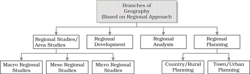
Fig 1.3: Branches of geography based on the regional approach
Two Threads That Run Through Every Branch
No matter which branch of geography you look at, whether systematic or regional, two aspects appear everywhere. They are the common threads that tie the entire discipline together.
Philosophy: The Ideas Behind the Science
The philosophical side of geography has two components:
- Geographical thought — The body of ideas, theories, and debates that have shaped how geographers think about the world. Every discipline has its intellectual traditions, and geography’s tradition stretches back thousands of years.
- Human ecology (land and human interaction) — The study of how people and their physical surroundings interact. How do communities depend on the land? How do they change it? This relationship sits at the very heart of what geography is about.
Methods and Techniques: The Practical Toolkit
Geography’s practical toolkit has grown enormously, and today it includes:
- Cartography (including computer cartography) — The creation of maps, now largely done digitally rather than by hand.
- Quantitative techniques (statistical techniques) — Mathematical and statistical methods for analysing spatial data and spotting patterns.
- Field survey methods — Techniques for collecting first-hand data through observation, measurement, and interviews directly on the ground.
- Geo-informatics — A modern umbrella term that brings together remote sensing (gathering information about the earth from satellites and aircraft), GIS (Geographic Information Systems, which store, analyse, and display spatial data), and GPS (Global Positioning System, which pinpoints exact locations on the earth’s surface).
A Discipline That Keeps Growing
One important thing to remember is that none of this classification is set in stone. Geography, like every living discipline, continues to grow and reshape itself as new ideas, new problems, and new technologies arrive.
Consider how dramatically the toolkit has changed in just a few decades. Manual cartography, where every map was drawn by hand, has given way to computer cartography, where maps are created, edited, and shared digitally. Technology now allows scholars to handle enormous volumes of data that would have been impossible to process earlier. The internet provides access to vast amounts of information from around the world, dramatically expanding the scale of analysis geographers can attempt.
GIS has been a game-changer, opening entirely new ways of seeing and understanding spatial patterns. GPS has become an everyday tool for finding exact locations quickly and accurately. Together, these technologies have greatly enhanced the geographer’s ability to carry out synthesis, the process of pulling together data, analysis, and theory into a complete, coherent picture of how spaces work.
The conclusion is encouraging: as tools get more powerful and new questions emerge, geography’s branches will continue to evolve. What you are learning today is a snapshot of a discipline that is always moving forward.